Find further information on the Conservation of Freshwater Ecosystem Values (CFEV) Program and its data at www.dpipwe.tas.gov.au/cfev.
TitleCatchment disturbance
CustodianWater and Marine Resources Division, Department of Primary Industries, Parks, Water and Environment
CreatorGIS Unit, Information and Land Services Division, DPIW
DescriptionAssessment of catchment impacts associated with land clearance and intensive land use practices.
Input data
Lineage
The catchment disturbance data layer was developed by dividing the state into three groups, according to the codes described in Table 1, which represented a combination of land clearance and land use data.
Table 1. Development of codes used to describe catchment disturbance.
Disturbance codes | Description | Comprised of: | Specific rules |
0 | Highest level of disturbance | TASVEG: cr (cleared) codes, BPN: 1 (cleared) and 2 (multiple selection events), LIST Land use categories: 3 to 5 (agricultural and intensive uses such as urban areas) | TASVEG codes took precedence over BPN codes, which took precedence over Land use codes. |
0.5 | Some disturbance | TASVEG: co (cut over) codes, LIST Land use category: 2.1.0 (rough grazing) | TASVEG codes took precedence over Land use codes. |
1 | Minimal or no disturbance | Everything else |
BPN codes 3 (single selective logging), 4 (unlogged since 1950) and 5 (unlogged) were not included because it was felt that these levels of disturbance (some of which took place over 50 years ago) were minimal.
The procedure is justified as follows: TASVEG ‘cr’ and ‘co’ data (highest level of precedence) provides the most recent figures of vegetation clearance, available to the CFEV Project. BPN codes 1 and 2 (next level) has more information at a consistently higher resolution.
The catchment disturbance data was assigned to River Section Catchments (RSCs) and then to each of the karst, river, waterbody and wetland spatial units (see below).
Data limitations
Doesn’t include data from forestry post-RFA (1997).
Date createdSeptember 2004
Scale and coverage1:25 000; Statewide
References
DPIW. (2003). TASVEG 0.1 May 2003. Tasmanian Monitoring and Mapping Program. Department of Primary Industries and Water, Hobart.
Harris, S. and Kitchener, A. (2003). Tasmania's vegetation: a technical manual for TASVEG, Tasmania's vegetation map: Version 1.0. (Draft). Department of Primary Industries, Water and Environment, Hobart.
Tasmanian Public Land Use Commission. (1997). Tasmanian-Commonwealth Regional Forest Agreement. National Estate Report. Tasmanian Public Land Use Commission in conjunction with Commonwealth Forest Taskforce, Hobart. 247 pp.
TitleCatchment disturbance
Column headingKT_CATDI, RS_CATDI, WB_CATDI, WL_CATDI
Input data
Type of dataContinuous but has been converted into categorical format (see Table 2).
Number of classesKarst = 5, Rivers = 5, Waterbodies = 5, Wetlands = 5
Assigning values to ecosystem spatial units
A catchment disturbance score (continuous number between 0 and 1) was assigned to each river, waterbody, wetland and karst spatial unit using the process outlined below. The final score incorporates the extent of catchment disturbance occurring within upstream catchments.
Firstly, using the CFEV catchment disturbance spatial data layer, the percentage area of each catchment disturbance code (0, 0.5 or 1) was calculated for each RSC. A single catchment disturbance score was then derived for each RSC using an area-weighted average. This was known as the catchment disturbance score for the local RSC.
The final catchment disturbance score for the RSC was calculated by accumulating the scores for all the upstream RSCs (including the local RSC) and weighting the values by the RSC’s current MAR values. In this accumulation, the boundaries of the upper catchment stopped where a RSC was directly downstream of a waterbody or a wetland of area >1 ha. This allowed for the influence of a waterbody/wetland acting as a sink for catchment-derived sedimentation. A diagram illustrating this process is presented in Figure 1.
The calculation of upstream accumulated catchment disturbance score for a given RSC is given by the following equation:

Where:
RSC_ACATDI = Accumulated catchment disturbance score for the RSC
RSC_CATDI (1…n) = Catchment disturbance score of the upstream RSCs
RSC_MAR (1…n) = Current MAR value of the upstream RSCs
RSC_CATDI = Catchment disturbance score of the local RSC
RSC_MAR = Current MAR value of the local RSC
RSC_AMARNM = Accumulated current MAR value for the RSC (includes the MAR of the local RSC)
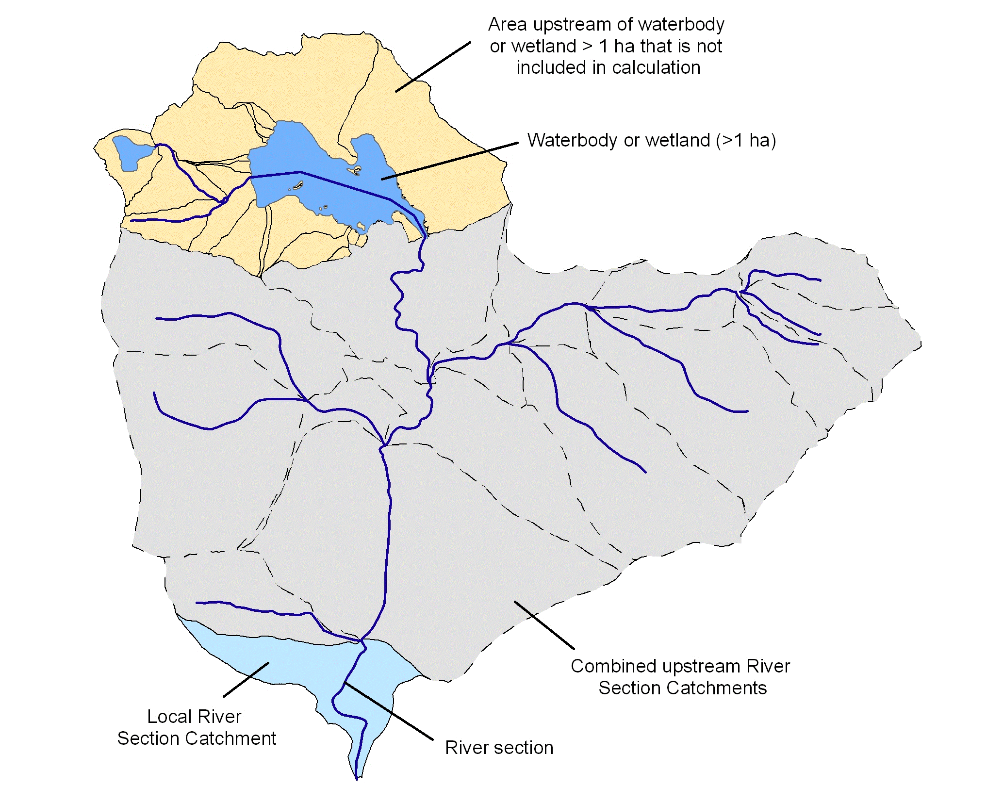
Figure 1. Illustration of catchments showing the local and upstream RSCs contributing to the calculation of the catchment disturbance scores. Dotted lines show RSC boundaries.
The range of catchment disturbance values was required to be between 0 and 1 for input into the condition expert rule systems, therefore the percent area of catchment disturbance was rescaled accordingly. Poor catchment condition is indicated with a score of 0 which equates to 100% catchment disturbance in the catchment, through to 1 being good/reference condition with 0% catchment disturbance.
Karst (KT_CATDI)
KT_CATDI = (Big river CATDI score*0.2) + (Small river CATDI score *0.8)
Where:
KT_CATDI = Catchment disturbance score of the karst spatial unit
Big river CATDI score = Catchment disturbance score for the karst spatial unit (only taking into account the RSCs of the karst local catchment which have RSC_AMARNM>42.8 GL) (calculated in Step 2)
Small river CATDI score = Catchment disturbance score for the karst spatial unit (only taking into account the RSCs of the karst local catchment which have RSC_AMARNM≤42.8 GL) (calculated in Step 3)
River sections (RS_CATDI)
Assign the catchment disturbance of the RSC (as calculated above) directly to the river section it is associated with.
Waterbodies (WB_CATDI)
Assign the catchment disturbance of the RSC (as calculated above) directly to the waterbody it is associated with.
Wetlands (WL_CATDI)
Calculate the area-weighted catchment disturbance score using each RSC associated with the wetland spatial unit and assign to the wetland spatial unit.
Each of the karst, river, waterbody and wetland spatial data layers had the continuous catchment disturbance data categorised according to Table 2. The categorical data was used for reporting and mapping purposes.
Table 2. Catchment disturbance categories for karst, rivers, waterbodies and wetlands.
Category | Rivers (Min to max values) | Waterbodies (Min to max values) | Wetlands (Min to max values) | |
1 | 0 | 0 to <0.05 | 0 | 0 |
2 | >0 to <0.05 | 0.05 to <0.6 | >0 to <0.05 | >0 to <0.05 |
3 | 0.05 to <0.95 | 0.6 to <0.8 | 0.05 to <0.95 | 0.05 to <0.95 |
4 | 0.95 to <1 | 0.8 to <0.95 | 0.95 to <1 | 0.95 to <1 |
5 | 1 | 0.95 to 1 | 1 | 1 |
CFEV assessment framework hierarchy