- the catchments of Port Davey and Bathurst Harbour
- King Island (with the exception of those river sections upstream and downstream of those waterbodies listed as stocked in Table 1)
- all river sections (and their associated waterbodies) upstream of the most downstream 100 m reach with a slope of 75% or greater
- all river sections (and their associated waterbodies) upstream of all mapped waterfall features (whether they are named or not) (LIST waterfall data)
- the river sections/waterbodies listed in Table 2.
- other unnamed lakes on the Mersey map sheet as per map in (Sloane and French 1991). Note: All waters upstream of the waters listed in this metadata are also trout free – whether connected by the drainage disconnected from the drainage.
- Those waterbodies listed in Table 3.
- river sections with fine substrates (sands, silts) or catchments dominated by such reaches (examples include the catchments of Crayfish Creek, Boobyalla River, Tomahawk River, Botanic Gardens Creek at Strahan). This occurs when slope is <10% and geology along the river section and/or in the immediate upstream catchment is predominantly (>50% by total channel length) one of the following types: undifferentiated Quaternary sediments (1:250 000 geology map Rcode 8493 ‘Q’), undifferentiated Cainozoic sediments (1:250 000 geology map Rcode 8494 ‘TQ’) or sand, gravel and mud of alluvial, lacustrine and littoral origin (1:250 000 geology map Rcode 8499 ‘Qh’)?
- in all catchments draining to the sea westwards from South-east Cape to Port Davey and from Port Davey to Cape Sorell
- all lakes in the central highlands to the east of and including Great Lake
- Swan River upstream of Hardings Falls
- Clarence Lagoon
- all Hydro lakes, storages and infrastructure, and river sections upstream for which the above rules do not apply
- artificial barriers such as all water storage lakes infrastructure and river sections upstream for which the above rules do not apply (e.g. Rileys Creek, Pet and Guide, etc.) as identified in Table 1.
Table 1. Waterbodies known to have sustained trout populations established by stocking (IFS trout stocking data).
WB_ID | Waterbody name | Unique Feature Identifier (UFI) (LIST) for those waterbodies not assessed by CFEV (e.g. farm dams, etc.) |
Pet | hyd004046581 | |
Guide | hyd004046579 | |
Kara | hyd004048543 | |
140 | Talbots Lagoon | |
Rileys Creek | hyd004916793 | |
Companion Reservoir | hyd004046580 | |
Mikany | hyd004676549 | |
144 | Lake Gairdner | |
166 | Lake Mackenzie | |
Rushy | hyd004129147 | |
131 | Curries River Reservoir | |
Cascade | hyd004214444 | |
Frome | hyd004214443 | |
Monarch | hyd004639583 | |
Near Lake Leake | hyd004923553 | |
1200 | Craigbourne Dam | |
1339 | Big Lagoon | |
1258 | Lake Skinner | |
Edgar Levee Pond | hyd005060875 | |
Mossy Marsh | hyd005004585 | |
Wentworth dam | hyd005009957 | |
Dunnys dam | hyd005009985 | |
Weasel Plains dam | hyd005287901 | |
West Queen Dam 2 | hyd004219156 | |
West Queen Dam 1 | hyd004219172 | |
West Queen Dam 3 | hyd004224338 | |
504 | Lake Augusta | |
902 | Little Pine Lagoon | |
638 | Lake Selina | |
1074 | Clarence Lagoon | |
1336 | Hartz Lake | |
1327 | Lake Perry | |
1328 | Lake Osborne | |
1258 | Lake Skinner | |
1230 | Lake Belton | |
1228 | Lake Belcher | |
1222 | Lake Seal | |
1229 | Lake Dobson | |
1224 | Lake Fenton | |
162 | Dove Lake | |
729 | Junction Lakes | |
650 | Lake Meston | |
152 | Lake Youl | |
622 | Lake Myrtle | |
557 | Lake Bill | |
148 | Lake Lea | |
995 | Lake Beatrice | |
1096 | Lake Bantick | |
619 | Lake Botsford | |
3 | Cask Lake (King Island) | |
201 | Lake Chambers | |
629 | Lake Chipman | |
527 | Lake Dudley | |
1101 | Lake Garcia | |
197 | Lake Johnny | |
836 | Langdon Lagoon (Brook Trout) | |
1098 | Lake Ashwood | |
1104 | Little Bellinger | |
562 | Little Blue Lake | |
1 | Lake Wickham (King Island) | |
723 | Lake Mikany | |
7 | Pennys Lagoon (King Island) | |
610 | Plimsoll (Brook Trout) | |
617 | Rocky Lagoon | |
628 | Second Lagoon | |
1258 | Lake Skinner | |
554 | Tin Hut Lake | |
1105 | Big Jim Lake | |
1130 | Highland Waters | |
1125 | Lake Samuel | |
1135 | Tooms Lake | |
939 | Lake Leake | |
1215 | Lake Webster | |
1217 | Twisted Tarn | |
1333 | Lake Esperance | |
1219 | Lake Hayes | |
1221 | Lake Nicholls | |
728 | Lake Rolleston | |
Waratah Reservoir | hyd005249767 | |
Bischoff Reservoir | hyd005249765 hyd005152411 hyd004739827 | |
Waratah Ponds | hyd005152405 hyd005152406 hyd005152407 |
Table 2. Trout-free river sections and waterbodies.
WB_ID | Site name | Map name | D/S limit of trout-free river section Easting | D/S limit of trout-free river section Northing |
Unnamed tributary of Olive Lagoon | Olive | 446700 | 5354875 | |
Johnsons Lagoon and headwaters | Olive | 447650 | 5350775 | |
Unnamed stream, Skullbone Plains | Ina | 449100 | 5346525 | |
Dyes Marsh and headwaters | Bronte Ina | 448400 | 5337500 | |
Tibbs Plain | Bronte | 440225 | 5336775 | |
Unnamed lagoon, Wentworth Hills | D’Arcys | 443525 | 5327400 | |
Swan River tributary | Henry St John | 591400 | 5367900 | |
Blue Tier Creek | Colonels | 562125 | 5337175 | |
Parramores Creek | Leake | 563800 | 5342100 | |
Tater Garden Creek – east | Colonels | 565100 | 5334050 | |
Tater Garden Creek – west | Colonels | 565100 | 5334050 | |
Snaky Creek | Colonels | 565100 | 5334050 | |
Tullochgorum Creek | Fingal | 580500 | 5383100 | |
St Pauls River | St John Fingal | 589450 | 5377500 | |
Dukes River | St John Fingal | 589450 | 5377500 | |
Lost Falls Creek | Leake | 573500 | 5344800 | |
Cygnet River | Snow | 573075 | 5355200 | |
Coghlans Creek | Ross Leake | 559500 | 5344100 | |
Green Tier Creek | Royalty Tooms | 561700 | 5317500 | |
Brodribb Creek | Leake | 568350 | 5342800 | |
Rocka Rivulet | Royalty Tooms | 563600 | 5318800 | |
835 | Lake Athena | |||
819 | Lake Pallas | |||
770 | Orion Lakes | |||
631 | Chalice Lake | |||
773 | Lake Merope | |||
786 | Lake Eros | |||
765 | Lake Artemis | |||
817 | Lake Payanna | |||
652 | Cloister Lagoon | |||
763 | Ling Roth Lakes | |||
896 | Lake Jackie | |||
lake on tributary of Lake Jackie to the north | ||||
455 | Lake Howe | |||
517 | New Years Lake | |||
437 | Lake Sidon | |||
408 | Lake Thor | |||
371 | George Howes Lake | |||
463 | Lake Salome | |||
452 | Lake Tyre | |||
510 | Hunters lake | |||
805 | Lake Norman |
Table 3. Trout-free waters within the Western Lakes – Central Plateau WHA area. Note: All waters upstream of these waters are also trout free – whether connected by the drainage or free standing.
WB_ID | Name |
1024 | Lake Sappho |
993 | Rim Lake |
892 | Lake Riengeena |
512 | Lake Louisa |
520 | Lake Adelaide |
Relative biomass
Native fish diversity is known to decline with distance from the coast in Tasmanian streams (Davies 1989) and is associated with a dominance of brown trout in mid and upper catchment reaches. Analysis of quantitative electro fishing survey data (including data derived by Davies (1989), and other unpublished data) from 84 Tasmanian river sites confirmed that the proportion of native fish biomass in riverine fish assemblages decreases with distance from the sea (the tidal limit) (Figure 1).
(a)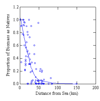
(b)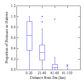
Figure 1. Proportion of fish biomass as native species declines with distance from the sea (data re-analysed from Davies (1989) and P. Davies, Freshwater Systems, unpublished data) (a) scatter plot showing the input data and the relationship between the two variables (line represents a spline fit) (b) box plot showing the median values when data was grouped into four distance classes, based on expert analysis of the data.
The exotic fish distribution was combined with biomass proportion information using a final set of rules for assigning an exotic fish index to river sections and waterbodies (given below). The exotic fish condition index spans from 0 (high probability of exotic fish; proportion of fish biomass as native fish = approx. zero) through 0.04, 0.32, 0.65 (high probability of exotic fish, proportion of fish biomass as native fish = 0.04, 0.32 or 0.65, respectively) and 0.8 (low probability of exotic fish) to 1 (exotic fish absent).
The numbers used here are the medians of the proportion of fish assemblage biomass that is made up of native species (PBNAT) as shown in the box plot in Figure 1b.
Data limitations
The exotic fish impact data is highly derived and inherits all the data limitations of the derivation processes and input data.
Date createdSeptember 2004
Scale and coverage1:25 000; Statewide
References
Davies, P.E. (1989). Relationships between habitat characteristics and population abundance for brown trout, Salmo trutta L. and blackfish, Gadopsis marmoratus Rich. in Tasmanian streams. Australian Journal of Marine and Freshwater Research 40: 341-359.
Sloane, R.D. and French, G.C. (1991). Trout Fishery Management Plan Western Lakes - Central Plateau Tasmanian World Heritage Area. Unpublished report to the Parks and Wildlife Service, Tasmania.
Column headingRS_EXOTICF, WB_EXOTICF
Type of dataCategorical
Number of classes6
Assigning values to ecosystem spatial units
River sections (RS_EXOTICF) and waterbodies (WB_EXOTICF)
An index, based on the proportion of the fish assemblage biomass that consists of native fish species was assigned to river sections and waterbodies using the following rules. Probabilities of the presence of exotic fish described in rules above. The distance the spatial units were from the sea (upstream point of the estuary) was calculated using the drainage network numbering system and cumulative river section lengths.
- If exotic fish probability = absent, assign score = 1 else
- If exotic fish probability = low, assign score = 0.8 else
- If exotic fish probability = present, then:
- if distance of river section or waterbody is 0-20 km from sea, then assign score = 0.65 else
- if distance of river section or waterbody is 21-40 km from sea, then assign score = 0.32 else
- if distance of river section or waterbody is 41-60 km from sea, then assign score = 0.04 else
- if distance of river section or waterbody is >60 km from sea, then assign score = 0
CFEV assessment framework hierarchy
- Rivers>Condition assessment>Naturalness score (RS_NSCORE)>Biological condition (RS_BIOL)
- Waterbodies>Condition assessment>Naturalness score (WB_NSCORE)>Native fish condition (WB_FISHCON)