Find further information on the Conservation of Freshwater Ecosystem Values (CFEV) Program and its data at www.dpipwe.tas.gov.au/cfev.
TitleLand use (nutrients)
CustodianWater and Marine Resources Division, Department of Primary Industries, Parks, Water and Environment
CreatorGIS Unit, Information and Land Services Division, Department of Primary Industries and Water (DPIW)
DescriptionEstimation of excess nutrient input to freshwater-dependent ecosystems.
Input data
Lineage
The land use (nutrients) data layer was developed by selecting LIST land use categories which are likely to result in excess nutrient input to freshwater-dependent ecosystems, particularly waterbodies and wetlands. Each land use category from the LIST data was given a score based on the relative impact it is likely to have on nutrient yield to freshwater-dependent ecosystems, either as 0.5 (moderate impact) or 0 (high to severe impact). A list of the selected land use categories and their assigned scores is given in Table 1. Areas of the state containing none of the LIST land use categories shown in Table 1 were assigned a nutrient score of 1 (no or very little impact). The land use (nutrients) data was attributed to each of the waterbody and wetland spatial units using the rules outlined below.
Table 1. Land use categories and their land use (nutrient) impact score.
Primary | Secondary | Tertiary | Nutrient score |
Production from dryland | Grazing modified pastures | Pasture legumes | 0.5 |
Production from dryland | Grazing modified pastures | Pasture legume/grass mixtures | 0.5 |
Production from dryland | Grazing modified pastures | Sown grasses | 0.5 |
Production from dryland | Cropping | Cropping | 0 |
Production from dryland | Cropping | Cereals | 0.5 |
Production from dryland | Cropping | Beverage and spice crops | 0.5 |
Production from dryland | Cropping | Hay and silage | 0.5 |
Production from dryland | Cropping | Oil seeds | 0.5 |
Production from dryland | Cropping | Sugar | 0 |
Production from dryland | Cropping | Cotton | 0.5 |
Production from dryland | Cropping | Tobacco | 0 |
Production from dryland | Cropping | Legumes | 0.5 |
Production from dryland | Perennial horticulture | Perennial horticulture | 0.5 |
Production from dryland | Perennial horticulture | Tree fruits | 0.5 |
Production from dryland | Perennial horticulture | Oleaginous fruits | 0.5 |
Production from dryland | Perennial horticulture | Tree nuts | 0.5 |
Production from dryland | Perennial horticulture | Vine fruits | 0.5 |
Production from dryland | Perennial horticulture | Shrub nuts fruits and berries | 0 |
Production from dryland | Perennial horticulture | Flowers and bulbs | 0 |
Production from dryland | Perennial horticulture | Vegetables and herbs | 0 |
Production from dryland | Seasonal horticulture | Seasonal horticulture | 0 |
Production from dryland | Seasonal horticulture | Fruits | 0 |
Production from dryland | Seasonal horticulture | Nuts | 0 |
Production from dryland | Seasonal horticulture | Flowers and bulbs | 0 |
Production from dryland | Seasonal horticulture | Vegetables and herbs | 0 |
Production from irrigation | Irrigated modified pastures | Irrigated modified pastures | 0.5 |
Production from irrigation | Irrigated modified pastures | Irrigated woody fodder plants | 0.5 |
Production from irrigation | Irrigated modified pastures | Irrigated pasture legumes | 0.5 |
Production from irrigation | Irrigated modified pastures | Irrigated legume/grass mixtures | 0.5 |
Production from irrigation | Irrigated modified pastures | Irrigated sown grasses | 0.5 |
Production from irrigation | Irrigated cropping | Irrigated cropping | 0 |
Production from irrigation | Irrigated cropping | Irrigated cereals | 0.5 |
Production from irrigation | Irrigated cropping | Irrigated beverage and spice crops | 0.5 |
Production from irrigation | Irrigated cropping | Irrigated hay and silage | 0.5 |
Production from irrigation | Irrigated cropping | Irrigated oil seeds | 0.5 |
Production from irrigation | Irrigated cropping | Irrigated sugar | 0 |
Production from irrigation | Irrigated cropping | Irrigated cotton | 0 |
Production from irrigation | Irrigated cropping | Irrigated tobacco | 0 |
Production from irrigation | Irrigated cropping | Irrigated legumes | 0 |
Production from irrigation | Irrigated perennial horticulture | Irrigated perennial horticulture | 0.5 |
Production from irrigation | Irrigated perennial horticulture | Irrigated tree fruits | 0.5 |
Production from irrigation | Irrigated perennial horticulture | Irrigated oleaginous fruits | 0.5 |
Production from irrigation | Irrigated perennial horticulture | Irrigated tree nuts | 0.5 |
Production from irrigation | Irrigated perennial horticulture | Irrigated vine fruits | 0.5 |
Production from irrigation | Irrigated perennial horticulture | Irrigated shrub nuts fruits and berries | 0.5 |
Production from irrigation | Irrigated perennial horticulture | Irrigated flowers and bulbs | 0 |
Production from irrigation | Irrigated perennial horticulture | Irrigated vegetables and herbs | 0 |
Production from irrigation | Irrigated perennial horticulture | Irrigated seasonal horticulture | 0 |
Production from irrigation | Irrigated perennial horticulture | Irrigated fruits | 0.5 |
Production from irrigation | Irrigated perennial horticulture | Irrigated nuts | 0.5 |
Production from irrigation | Irrigated perennial horticulture | Irrigated flowers and bulbs | 0 |
Production from irrigation | Irrigated perennial horticulture | Irrigated vegetables and herbs | 0 |
Intensive uses | Intensive horticulture | Intensive horticulture | 0 |
Intensive uses | Intensive horticulture | Shadehouses | 0.5 |
Intensive uses | Intensive horticulture | Glasshouses | 0.5 |
Intensive uses | Intensive horticulture | Glasshouses (hydroponic) | 0.5 |
Intensive uses | Intensive animal production | Intensive animal production | 0 |
Intensive uses | Intensive animal production | Dairy | 0 |
Intensive uses | Intensive animal production | Cattle | 0 |
Intensive uses | Intensive animal production | Sheep | 0 |
Intensive uses | Intensive animal production | Poultry | 0 |
Intensive uses | Intensive animal production | Pigs | 0 |
Intensive uses | Intensive animal production | Aquaculture | 0 |
Intensive uses | Manufacturing and industrial | Manufacturing and industrial | 0.5 |
Intensive uses | Residential | Residential | 0.5 |
Intensive uses | Residential | Urban residential | 0 |
Intensive uses | Residential | Rural residential | 0.5 |
Intensive uses | Services | Services | 0.5 |
Intensive uses | Services | Commercial services | 0.5 |
Intensive uses | Services | Public services | 0.5 |
Intensive uses | Services | Recreation and culture | 0.5 |
Intensive uses | Transport and communication | Airports/aerodromes | 0.5 |
Intensive uses | Transport and communication | Roads | 0.5 |
Intensive uses | Transport and communication | Railways | 0.5 |
Intensive uses | Transport and communication | Ports and water transport | 0.5 |
Intensive uses | Transport and communication | Navigation and communication | 0.5 |
Intensive uses | Waste treatment and disposal | Waste treatment and disposal | 0 |
Intensive uses | Waste treatment and disposal | Stormwater | 0.5 |
Intensive uses | Waste treatment and disposal | Landfill | 0 |
Intensive uses | Waste treatment and disposal | Solid garbage | 0 |
Intensive uses | Waste treatment and disposal | Incinerators | 0 |
Intensive uses | Waste treatment and disposal | Sewage | 0 |
Water | Reservoir/dam | Evaporation basin | 0.5 |
Water | Reservoir/dam | Effluent pond | 0 |
Water | River | River - intensive use | 0.5 |
Water | Marsh/wetlands | Marsh/wetland - intensive use | 0.5 |
Water | Estuaries/coastal waters | Estuary/coastal water - intensive use | 0.5 |
Data limitations
The land use (nutrients) data inherits all the limitations of the input data, and also relies heavily upon the expert assessment of the relative impacts of each of the land uses.
Date createdSeptember 2004
Scale and coverage1: 25 000, Statewide
TitleLand use (nutrients)
Column headingWB_NUTRI, WL_NUTRI
Input data
Type of dataContinuous but also exists in a categorical format (see Table 2).
Number of classesWaterbodies = 5, Wetlands = 5
Assigning values to ecosystem spatial units
A land use (nutrients) score (continuous number between 0 and 1) was assigned to each waterbody and wetland spatial unit using the following process.
Firstly, the land use (nutrients) spatial data layer was intersected with the RSC data layer and for each RSC (which sometimes is a waterbody catchment) and wetland catchment, the percentage area of the catchment containing each nutrient score (0, 0.5 or 1) was calculated. Note in the case of wetlands, the catchment may be made up of more than one RSC. A single score for the catchment was then calculated using an area-weighted average. A further step involved taking this value and assigning a final nutrient score for the catchment according to the following rules:
This value was known as the land use (nutrients) score for the local catchment. For wetlands, this score was assigned directly to the wetland spatial unit as WL_NUTRI.
Nutrient scores for the waterbodies, however, were accumulated for all upstream RSCs, (including the local waterbody catchment) and weighted by the current MAR. In this accumulation, the boundaries of the upper catchment stopped where a RSC was directly downstream of a waterbody or a wetland of area >1 ha. This allowed for the influence of a waterbody/wetland acting as a sink for catchment-derived sedimentation (illustrated in Figure 1Figure ).
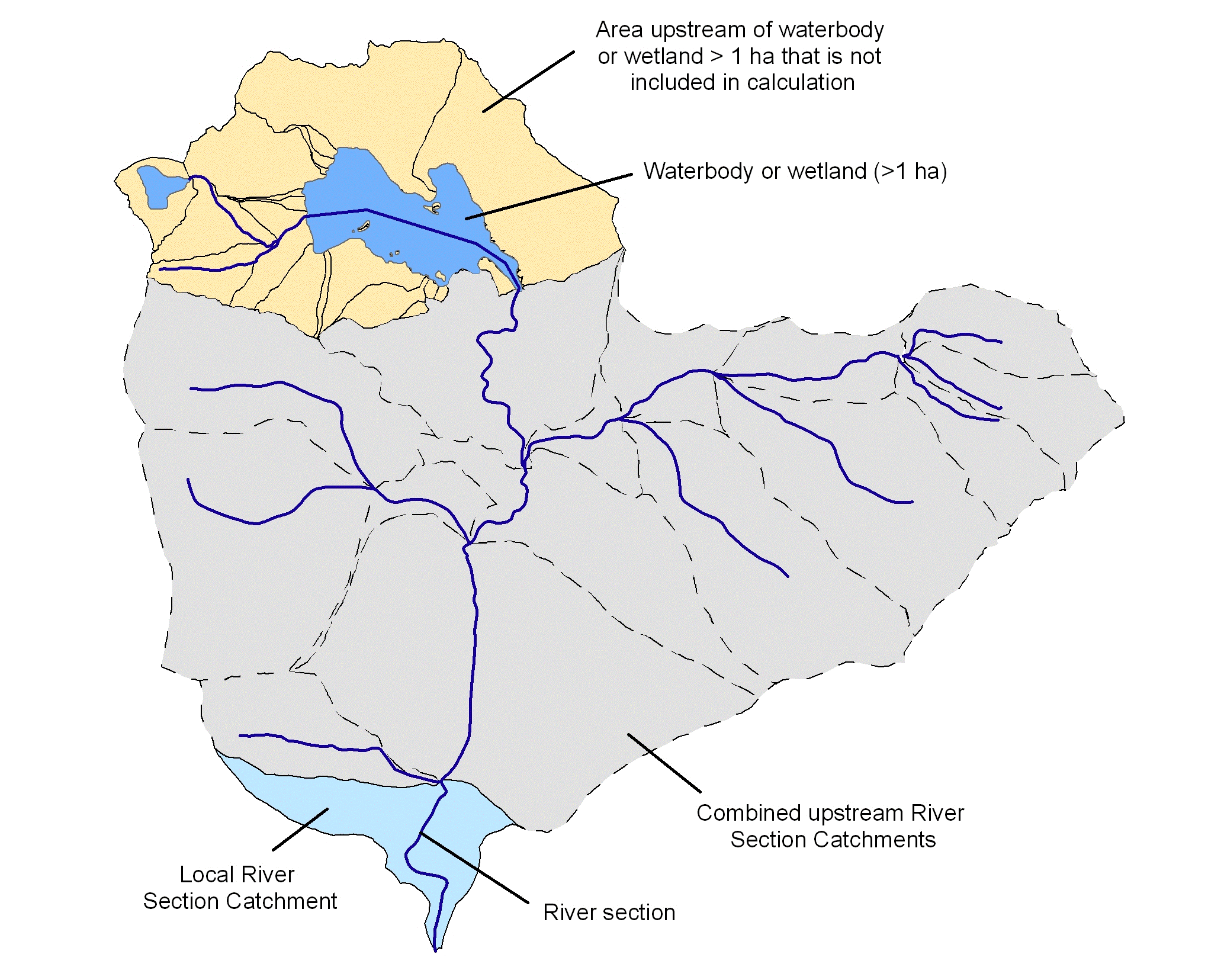
Figure 1. Illustration of catchments showing the local and upstream RSCs contributing to the calculation of the catchment disturbance scores. Dotted lines show RSC boundaries.
The calculation of upstream accumulated land use (nutrients) score for a given waterbody catchment is given by the following equation:

Where:
RSC_ANUTRI = Accumulated land use (nutrients) score for the RSC (waterbody catchment)
RSC_NUTRI (1…n) = Land use (nutrients) score of the upstream RSCs
RSC_MAR (1…n) = Current MAR value of the upstream RSCs
RSC_NUTRI = Land use (nutrients) score of the local RSC (waterbody catchment)
RSC_MAR = Current MAR value of the local RSC
RSC_AMARNM = Accumulated current MAR value for the RSC (includes the MAR of the local RSC)
The upstream accumulated land use (nutrients) score for the waterbody catchment was then assigned directly to the relevant waterbody spatial unit. The overall land use (nutrient) scores range from 0 (poor condition – high nutrient input) to 1 (natural or near-natural condition – low nutrient input).
Each of the waterbody and wetland spatial data layers had the continuous land use (nutrients) data categorised according to Table 2. The categorical data was used for reporting and mapping purposes.
Table 2. Land use (nutrient) categories for waterbodies and wetlands.
Category | Waterbodies (Min to max values) | Wetlands (Min to max values) |
1 | 0 | 0 |
2 | >0 to <0.05 | >0 to <0.05 |
3 | 0.05 to <0.95 | 0.05 to <0.95 |
4 | 0.95 to <1 | 0.95 to <1 |
5 | 1 | 1 |
CFEV assessment framework hierarchy