Find further information on the Conservation of Freshwater Ecosystem Values (CFEV) Program and its data at www.dpipwe.tas.gov.au/cfev.
TitleCFEV River Section Catchments (RSCs)
CustodianWater and Marine Resources Division, Department of Primary Industries, Parks, Water and Environment
CreatorJohn Corbett, GIS Unit, Information and Land Services Division, Department of Primary Industries and Water (DPIW)
DescriptionCatchment boundaries for all individual CFEV river sections, waterbodies and estuaries of Tasmania
Input data
Lineage
The RSC spatial data layer was developed in several phases, in conjunction with the rivers spatial data layer as an overall catchment model (see details below). This data layer is a highly detailed sub-catchment subdivision of the state, corresponding to internodal reaches (river sections) of the drainage network, with linkage information appropriate for larger scale aggregation of catchments.
1. Building a triangulated interlaced network (TIN) and catchment polygons
Using specially developed software, Landscape Mapper, all of the information from the contour, water course, pipe, lake, coastline and estuary closure layers were meshed into a single three-dimensional data structure and the coordinates triangulated to form a continuous meshed surface model of the state (a TIN). Coordinate elevations for contour and lake coordinates came from the original layer attributes. The coastline and estuary closure coordinates were given an elevation of 0 m. Water course coordinate elevations were interpolated between contour intersections, ensuring wherever possible that all water courses ran downhill. Since pipes do not necessarily follow the surface of the earth, they were given arbitrary elevations in the model.
Additional ridge and valley breakline coordinates were added to ensure that the implied water flow from the surface model coincided with the flow implied by the rivers spatial data layer and to interpolate elevations in areas with little relief information. This included a process of draining surface sink areas wherever possible.
With a drainage-consistent surface model, catchment divider lines were automatically calculated so that the surface would be partitioned into catchment regions corresponding with catchment seed points. In particular, a catchment polygon was created for each internodal stream reach (river section), for each lake (waterbody) (corresponding exactly to the lake polygon itself), for each surface sink, for each estuary (as defined by the coastline and estuary closures), and for all remaining areas (consisting of areas draining directly to the coast or to a lake edge). The resulting RSC data layer contained 476 857 catchment regions.
2. Accumulating drainage downstream to the ocean
To chart the course of water from its initial raindrop on the model surface to the ocean, a unique flow path was required. In many cases this flow path was ambiguous, due to multiple possible drainage routes. Without a unique flow path for each point on the model surface, the concept of a catchment area is ill-defined. To get around this problem, all but one possible drainage route was ignored during the flow calculation.
To determine which path was to be the ‘primary flow path’, a combination of manual and automatic methods was used. In areas regulated by Hydro Tasmania control (i.e. pipes and other Hydro infrastructure), an ‘ideal flow path’ was implied on the drainage, representing the most common or dominant flow over the course of a typical year. In all other areas, a flow path was automatically selected according to the following rules:
The ‘ideal flow path’ is represented in the rivers spatial data layer by an attribute linking each river section to the next river section downstream along the ‘ideal flow path’.
Flow paths from the drainage network were transferred to the corresponding catchments in this RSC spatial data layer, allowing a flow network to be created. However, there were still places in which the flow of water to the ocean was not well defined. These instances were represented as sinks in the catchment flow network and had numerous causes. Some of the possible causes were:
In such cases there was no clear method for determining the flow of water from catchment to catchment. The solution used was to progressively fill each sink catchment with water until there was overflow into a neighbouring lower catchment area. The outflow from the sink catchment was then redirected to this new catchment, thus ensuring that all water would eventually drain to the ocean. This connectivity was also mapped back to the drainage layer so that drainage sinks would be ‘virtually connected’ to an area of a downstream drainage network.
Similar to the drainage network, two versions of the catchment layer exists in terms of connectivity (Natural – never flows down pipes and Current – flow takes predominant flow path including pipes).
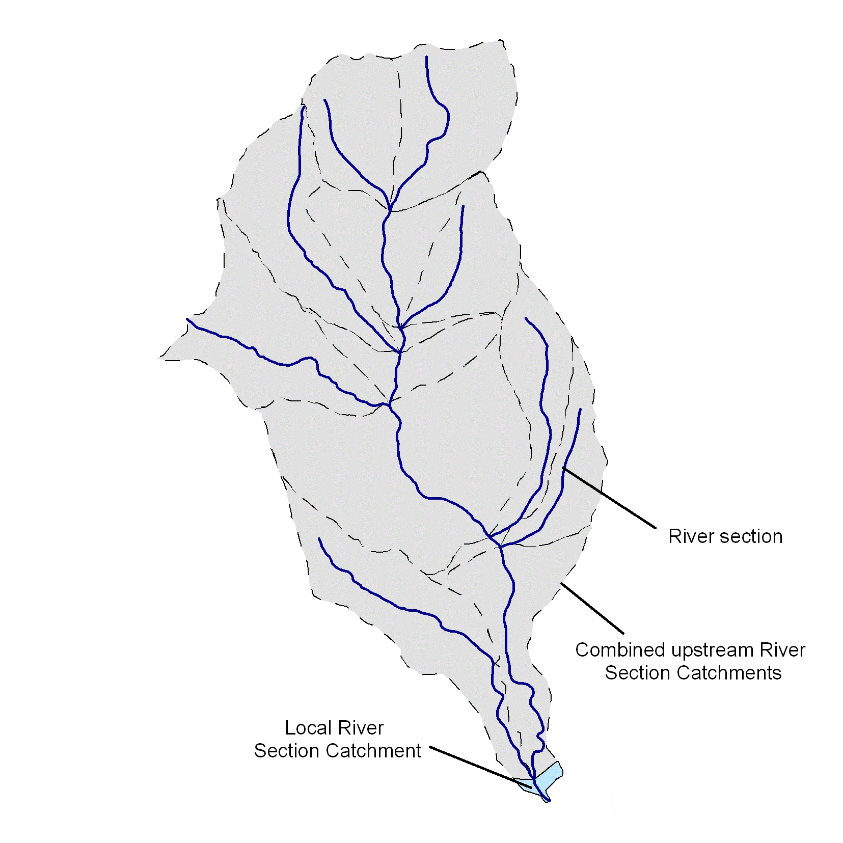
For many of the condition assessment variables, local catchment and upstream catchment scores were calculated and combined to give an overall condition score. Scores were calculated for each of the RSCs in this data layer. The local RSC is an individual polygon in this layer and the upstream catchment includes all RSCs upstream of it (see Figure 1 for an illustration). Scores for the local and upstream catchments were often combined to give an overall condition score and then assigned to the river sections.

Figure 1. Illustration of catchments showing the local and upstream (consisting of multiple) RSCs. Dotted lines show RSC boundaries.
Data limitations
Limitations of this data layer are closely associated with those of the CFEV rivers spatial data set. The drainage network is linked by attributes but is not fully linked spatially. Small unconnected sections have been removed. The sink-draining algorithm has taken a ‘best guess’ approach when deciding which path water takes.
Date createdDecember 2004
Scale and coverage1:25 000; Statewide (excluding Macquarie Island)
Other comments
The RSCs were aggregated to develop the CFEV sub-catchment and catchment data layers. These data layers make up a nested set of catchments for Tasmania.